
The project
For the municipality of Veldhoven, Clappform is executing the Integrated Neighbourhood Scan in the Cobbeek and D'Ekker neighbourhoods, with the aim of improving the living environment for elderly residents. By combining objective data with resident experiences, a current and widely supported overview of the situation in both neighbourhoods is established.
This provides the municipality with insights into aspects such as social cohesion, mobility, meeting places, and the quality of the physical environment. The results form a foundation for district visions, the Public Housing Programme, and concrete improvement initiatives at both district and neighbourhood levels. In this way, the municipality can transition from insight to analysis and from analysis to action, enabling proactive policy-making.
Applied data
Statistics Netherlands (CBS) key figures per district and neighbourhood
GGD Health Monitor
Climate Impact Atlas and Liveabilityometer
Mobility and walking routes
Socio-economic characteristics
Amenities and distance analyses
Greenery, outdoor space, and public space
Loneliness scores and social cohesion
Notifications and alerts from the neighbourhood
Resident participation input (workshops, walking interviews)
Police data
Safety and liveability indicators

The challenge
The Veldhoven districts of Cobbeek and D’Ekker have a relatively high concentration of elderly residents. Compared to neighbourhoods with a younger demographic, older residents here experience higher levels of loneliness, which is linked to their limited mobility. However, the available data on mobility, health, quality of life, and amenities is scattered across various sources and is not updated frequently enough to enable targeted management. As a result, there was no up-to-date, comprehensive, and widely supported overview of the local situation. The challenge for the Municipality of Veldhoven and Clappform was to combine this objective data with the lived experiences of residents, in order to develop a targeted neighbourhood approach focused on creating an active and social living environment.
Our solution
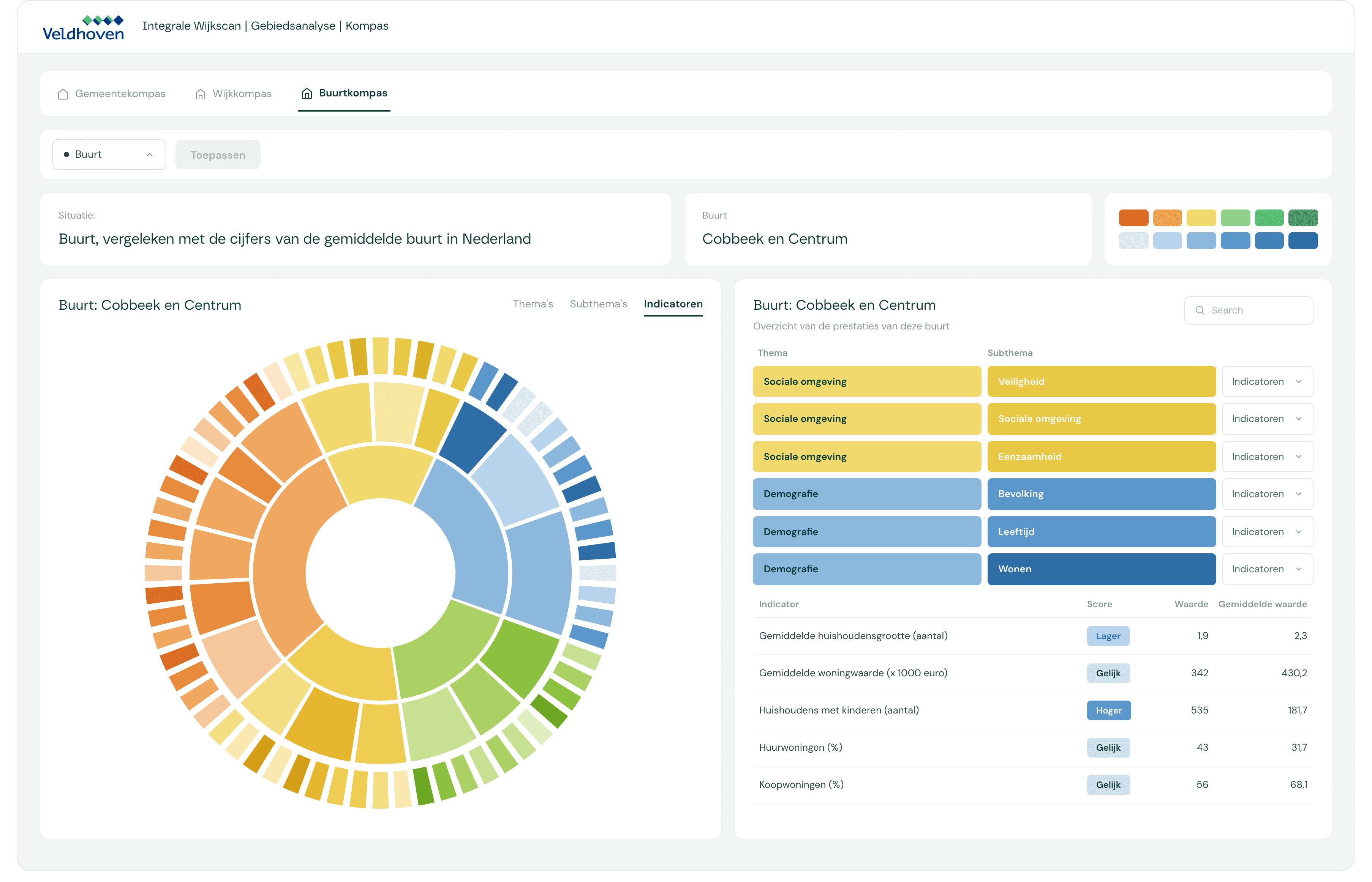
The Integrated Neighbourhood Scan provides insight into the living environment at municipal, district, and neighbourhood levels, consolidated into a single dashboard. Based on the RIVM's Basic Set of Indicators for a Healthy Living Environment, the application visualises the social and physical characteristics of each area. This enables the Municipality of Veldhoven to make decisions based on a combination of public and local data within the municipality.
Within the Integrated Neighbourhood Scan, the municipality can, among other things:
combine current district and neighbourhood data with feedback from residents;
analyse themes such as loneliness, mobility, green space and meeting places;
visualise bottlenecks and opportunities per street or area;
directly link participation input to objective data in a single dashboard;
prioritise area-based measures with community support from the neighbourhood;
integrate results into neighbourhood visions, implementation plans and the Housing Programme;
export reports for use within policy, management or partners.
ZonMw Project Collaboration
The Integrated Neighbourhood Scan in Veldhoven has been set up in collaboration with ZonMw projects. Read more about this in the following article: ZonMw Article.
Start today
How we assist municipalities with their data challenges
Within a municipality, various themes are at play: from housing and livability to sustainability, safety, and the social domain. These domains directly pertain to area development and require up-to-date, reliable data.
Whether it involves resource allocation, prioritizing policy interventions, or monitoring neighborhood developments, real-time insights help municipalities steer sharply, make well-founded decisions, and respond flexibly to change.
Clappform provides municipalities with a platform that translates complex data into clear, actionable insights. Through direct connections with data sources and thematic dashboards, the information seamlessly aligns with policy-related questions.